El Niño’s Escalating Toll: A Guide to Understanding Amplified Climate Extremes
Overview
The cyclical warming of the tropical Pacific Ocean, known as El Niño, has always brought disruptive weather across the globe. But as researchers made clear in a recent briefing, the same moderate or strong El Niño events that occurred a few decades ago now pack a far greater punch. This guide explains why – and what to expect – based on current scientific understanding. We'll break down the phenomenon, its interaction with a warmer climate system, and the specific extremes (wildfires, floods, severe heatwaves) that forecasters are warning about.
Prerequisites
Before diving into the mechanisms, you should be familiar with a few basic concepts:
- El Niño-Southern Oscillation (ENSO): A natural climate pattern involving sea surface temperature changes in the equatorial Pacific.
- Climate change: The long-term warming of the planet due to human emissions of greenhouse gases, especially from burning fossil fuels.
- Anomaly: A departure from the long-term average, used in climate science to compare current conditions to a baseline.
No specialized software or data access is required – just a willingness to understand how natural variability and human-caused warming combine.
Step-by-Step Guide: How El Niño Amplifies Climate Extremes
Step 1: Recognize El Niño as the Warm Phase of ENSO
El Niño is the warm phase of a semi-regular temperature oscillation in the tropical Pacific Ocean. During this phase, massive amounts of heat stored in the ocean are released into the atmosphere. This release temporarily raises the average annual global surface temperature by as much as 0.3°F (about 0.17°C). Learn why this heat matters next.
Step 2: Understand the Background Warming Context
The critical nuance is that the entire global climate system is now substantially warmer than it was a few decades ago. This long-term warming – driven mainly by burning fossil fuels – does not pause during an El Niño. Instead, the two effects stack. An El Niño event today begins from a higher baseline temperature, so the same oceanic pulse of heat results in more extreme absolute temperatures and more energetic weather systems.
Step 3: Map the Amplified Extremes
Forecasters predict three types of extreme events will be exacerbated by an incoming El Niño:
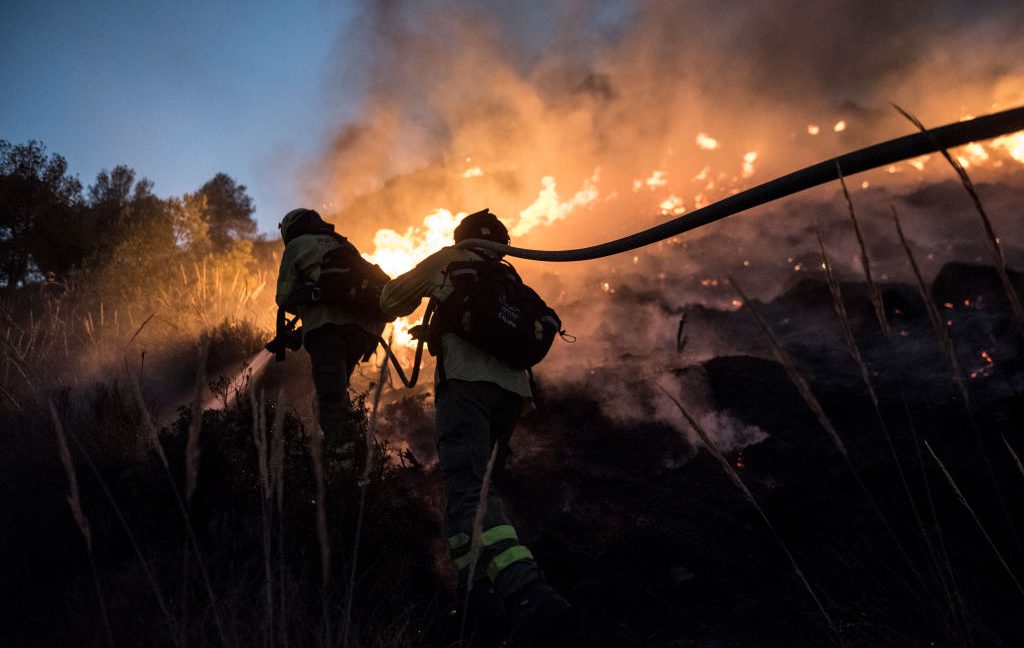
- Wildfires: Warmer and drier conditions in many regions, especially western North America and parts of the Amazon, increase vegetation flammability and fire spread.
- Floods: Enhanced atmospheric moisture and altered jet stream patterns can lead to heavy rainfall events, particularly in normally wet areas like the southern United States and parts of South America.
- Severe heatwaves: The combination of the El Niño heat pulse and underlying global warming pushes temperatures beyond what would occur from either factor alone, breaking records across continents.
These are not hypothetical: during a 2023-2024 El Niño, many of these impacts were observed. The researchers emphasized that a moderate or strong El Niño today causes more damage than an identical event in the 1990s because the climate system is now hotter.
Step 4: Monitor Oceanic and Atmospheric Indicators
Scientists use sea surface temperature anomalies in the Niño 3.4 region (5°N–5°S, 120°W–170°W) to track El Niño strength. When anomalies exceed +0.5°C for several months, an El Niño is declared. Forecasters also watch for weakening trade winds and shifts in the Walker Circulation. These indicators, combined with climate models, allow early warning of the amplified extremes described above.
For a real‑time example, check the NOAA Climate Prediction Center ENSO updates.
Common Mistakes
- Confusing El Niño with climate change: El Niño is a natural short-term oscillation. Climate change is long-term warming caused by human activities. While they interact, they are not the same phenomenon.
- Ignoring the baseline: Some assume the 0.3°F global temperature increase from El Niño is the only effect. In reality, it adds to an already elevated baseline, making extremes worse than they would be otherwise.
- Thinking past El Niños were equally impactful: Because the planet is now warmer, the same moderate El Niño in 1997 and 2023 produced very different outcomes. This mistake leads to under-preparation.
- Expecting uniform impacts globally: El Niño’s effects are region-specific. Some areas (e.g., parts of Southeast Asia) may actually become drier, while others flood. Always check regional forecasts.
Summary
El Niño releases stored ocean heat, temporarily raising global temperatures ~0.3°F. Because the climate system is now substantially warmer due to fossil fuel burning, the same El Niño today causes more severe wildfires, floods, and heatwaves than similar events decades ago. Understanding this stacking effect is key to interpreting modern forecasts and preparing for amplified extremes.
Related Articles
- KAME: Sakana AI’s Tandem Speech-to-Speech Architecture Combines Speed and Knowledge
- How to Host a Presidential Reception for NASA's Moon Mission Astronauts
- How to Pinpoint the Culprit in Multi-Agent System Failures: A Step-by-Step Guide Using Automated Failure Attribution
- Mathematician Declares Infinity a Myth: Universe 'Ticks' Like a Machine
- 3 Key Pathways to Room-Temperature Quantum Materials for Cooler Computing
- Mastering Semantic Search: A Step-by-Step Guide to Vector Databases and Beyond
- Dreame Unveils Rocket-Powered EV Promising 0-60 in 0.9 Seconds – Claims Met With Skepticism
- Automated Failure Attribution in Multi-Agent LLM Systems: A New Benchmark and Methods